Groundwater Disappearing Much Faster Than Lake Mead in Colorado River Basin

The mineral-stained canyon walls and the plunging water levels at Lake Mead, the nation’s largest reservoir, are the most visible signs of the driest 14-year period in the Colorado River Basin’s historical record.
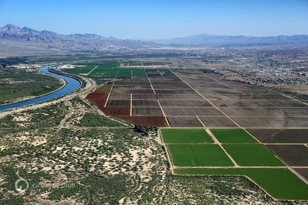
But the receding shorelines at the Basin’s major reservoirs—including Lake Mead, which fell to a record-low level this month, and Lake Powell, the second largest reservoir on the Colorado, 290 kilometers (180 miles) upstream from Mead—are an insignificant hydrological change compared to the monumental disruption taking place underground.
Satellite data show that in the last nine years, as a powerful drought held fast and river flows plummeted, the majority of the freshwater losses in the Basin—nearly 80 percent—came from water pumped out of aquifers.
The decrease in groundwater reserves is a volume of water equivalent to one and a half times the amount held in a full Lake Mead, according to a study published today in the journal Geophysical Research Letters.
“We didn’t think it would be this bad,” said Stephanie Castle, a researcher at the University of California, Irvine, and the study’s lead author. “Basin-wide groundwater losses are not well documented. The number was shocking.”
Scales in the Sky
The research team used data from the GRACE satellite mission to calculate the water balance for a Basin that spreads across seven states and reaches into Mexico.
Launched in 2002, GRACE is a pair of satellites that translate fluctuations in the Earth’s gravitational pull into changes in total water storage. Separate data sets are used to pull apart the contributions from snowpack, soil moisture, surface water and groundwater. GRACE data has been used to assess groundwater depletion in California and the Middle East, as well as flood potential in the Missouri River Basin.
Jay Famiglietti, an Earth systems professor at the University of California, Irvine, and a study co-author, calls the instruments “scales in the sky.”
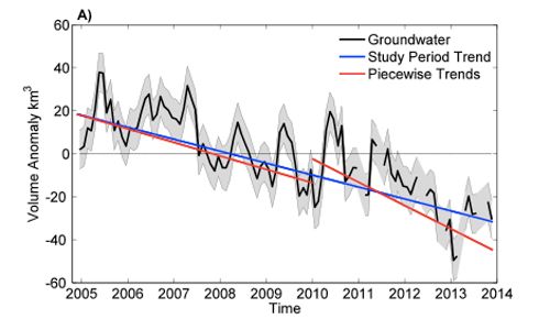
For the study, the researchers looked at the period from December 2004 to November 2013. This time frame allowed them to isolate the effects of the drought on groundwater. By 2004, the Basin’s reservoirs were nearing record lows. Today, they are slightly, but not significantly lower, at 51 percent full.
The steepest rates of water loss occurred in 2013, which followed one of the driest years on record.
The total decline in the Basin’s water reserves was 64.8 cubic kilometers (52.5 million acre-feet), with 50.1 cubic kilometers (40.6 million acre-feet) from groundwater. The capacity of Lake Mead, for comparison, is 32 cubic kilometers (26 million acre-feet). At least 70 percent of the Basin’s water use is for irrigated agriculture.
Chuck Collum, Colorado River manager at the Central Arizona Project, which delivers more than half of Arizona’s Colorado River allocation, said the study was helpful.
“The study is useful in using GRACE to verify at a coarse scale what water managers in the Basin know,” Cullom told Circle of Blue.
To check their conclusions, the researchers compared the satellite data against measurements taken from individual wells. Measurements from nine U.S. Geological Survey wells and 65 Arizona Department of Water Resources wells showed similar trends at the smaller scale.
“That gives us confidence in what GRACE is seeing,” Castle said.
Still, GRACE data has limits. For one, the satellites cannot tell what share of the groundwater decline comes from an increase in pumping versus a decrease in the recharge rate, the amount that flows into an aquifer. In a drought, pumping would be expected to go up and recharge down, Famiglietti said.
GRACE also has spatial constraints. The satellites work best for land areas larger than 200,000 square kilometers (77,220 square miles), roughly the size of Nebraska. The satellites cannot pick out hotspots of groundwater depletion within the states.
“It’s difficult to break GRACE data down farther than we have,” Famiglietti told Circle of Blue. “We need additional data on the ground to tell what is happening.”
You Might Also Like
America’s Largest Reservoir Drains to Record Low As Western Drought Deepens
Drought Drains Lake Mead to Lowest Level as Nevada Senator Calls for Government Audit
Extreme Drought in CA Triggers Halting of Fracking Waste Injection to Avoid Aquifer Contamination
A tornado tore through a city north of Birmingham, Alabama, Monday night, killing one person and injuring at least 30.
- Tornadoes and Climate Change: What Does the Science Say ... ›
- Tornadoes Hit Unusually Wide Swaths of U.S., Alarming Climate ... ›
- 23 Dead as Tornado Pummels Lee County, AL in Further Sign ... ›
EcoWatch Daily Newsletter
By David Konisky
On his first day in office President Joe Biden started signing executive orders to reverse Trump administration policies. One sweeping directive calls for stronger action to protect public health and the environment and hold polluters accountable, including those who "disproportionately harm communities of color and low-income communities."
Michael S. Regan, President Biden's nominee to lead the U.S. Environmental Protection Agency, grew up near a coal-burning power plant in North Carolina and has pledged to "enact an environmental justice framework that empowers people in all communities." NCDEQ
Trending
By Katherine Kornei
Clear-cutting a forest is relatively easy—just pick a tree and start chopping. But there are benefits to more sophisticated forest management. One technique—which involves repeatedly harvesting smaller trees every 30 or so years but leaving an upper story of larger trees for longer periods (60, 90, or 120 years)—ensures a steady supply of both firewood and construction timber.
A Pattern in the Rings
<p>The <a href="https://www.encyclopedia.com/science/dictionaries-thesauruses-pictures-and-press-releases/coppice-standards-0" target="_blank">coppice-with-standards</a> management practice produces a two-story forest, said <a href="https://www.researchgate.net/profile/Bernhard_Muigg" target="_blank">Bernhard Muigg</a>, a dendrochronologist at the University of Freiburg in Germany. "You have an upper story of single trees that are allowed to grow for several understory generations."</p><p>That arrangement imprints a characteristic tree ring pattern in a forest's upper story trees (the "standards"): thick rings indicative of heavy growth, which show up at regular intervals as the surrounding smaller trees are cut down. "The trees are growing faster," said Muigg. "You can really see it with your naked eye."</p><p>Muigg and his collaborators characterized that <a href="https://ltrr.arizona.edu/about/treerings" target="_blank">dendrochronological pattern</a> in 161 oak trees growing in central Germany, one of the few remaining sites in Europe with actively managed coppice-with-standards forests. They found up to nine cycles of heavy growth in the trees, the oldest of which was planted in 1761. The researchers then turned to a historical data set — more than 2,000 oak <a href="https://eos.org/articles/podcast-discovering-europes-history-through-its-timbers" target="_blank" rel="noopener noreferrer">timbers from buildings and archaeological sites</a> in Germany and France dating from between 300 and 2015 — to look for a similar pattern.</p>A Gap of 500 Years
<p>The team found wood with the characteristic coppice-with-standards tree ring pattern dating to as early as the 6th century. That was a surprise, Muigg and his colleagues concluded, because the first mention of this forest management practice in historical documents occurred only roughly 500 years later, in the 13th century.</p><p>It's probable that forest management practices were not well documented prior to the High Middle Ages (1000–1250), the researchers suggested. "Forests are mainly mentioned in the context of royal hunting interests or donations," said Muigg. Dendrochronological studies are particularly important because they can reveal information not captured by a sparse historical record, he added.</p><p>These results were <a href="https://www.nature.com/articles/s41598-020-78933-8" target="_blank">published in December in <em>Scientific Reports</em></a>.</p><p>"It's nice to see the longevity and the history of coppice-with-standards," said <a href="https://www.teagasc.ie/contact/staff-directory/s/ian-short/" target="_blank">Ian Short</a>, a forestry researcher at Teagasc, the Agriculture and Food Development Authority in Ireland, not involved in the research. This technique is valuable because it promotes conservation and habitat biodiversity, Short said. "In the next 10 or 20 years, I think we'll see more coppice-with-standards coming back into production."</p><p>In the future, Muigg and his collaborators hope to analyze a larger sample of historic timbers to trace how the coppice-with-standards practice spread throughout Europe. It will be interesting to understand where this technique originated and how it propagated, said Muigg, and there are plenty of old pieces of wood waiting to be analyzed. "There [are] tons of dendrochronological data."</p><p><em><a href="mailto:katherine.kornei@gmail.com" target="_blank" rel="noopener noreferrer">Katherine Kornei</a> is a freelance science journalist covering Earth and space science. Her bylines frequently appear in Eos, Science, and The New York Times. Katherine holds a Ph.D. in astronomy from the University of California, Los Angeles.</em></p><p><em>This story originally appeared in <a href="https://eos.org/articles/tree-rings-reveal-how-ancient-forests-were-managed" target="_blank">Eos</a></em> <em>and is republished here as part of Covering Climate Now, a global journalism collaboration strengthening coverage of the climate story.</em></p>Earth's ice is melting 57 percent faster than in the 1990s and the world has lost more than 28 trillion tons of ice since 1994, research published Monday in The Cryosphere shows.
By Jewel Fraser
Noreen Nunez lives in a middle-class neighborhood that rises up a hillside in Trinidad's Tunapuna-Piarco region.