
 568k
568k  233k
233k  41k
41k  Subscribe
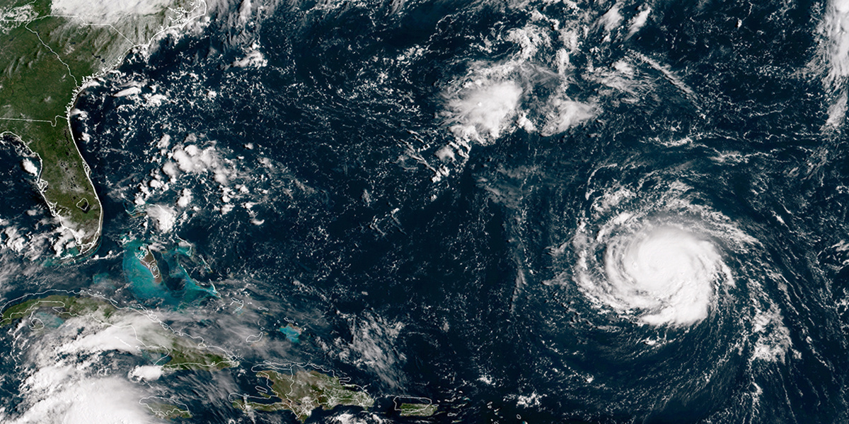
After starting off as a tropical storm, Florence has rapidly intensified and is expected to become a major
hurricane that could make landfall in North and South Carolina later this week.
The storm is now a Category 4 hurricane, the National Hurricane Center’s Atlantic branch tweeted in its latest update Monday.
“Florence has continued to rapidly strengthen and has maximum sustained winds near 130 mph (195 km/h) and a minimum central pressure of 946 mb (27.93 inches),” the agency wrote.
Meteorologist Eric Holthaus
tweeted Sunday that Florence “is going to be about the size of North Carolina when it arrives.”
Holthaus added that if Florence arrives on the coast as a Category 4, it could “potentially become the strongest East Coast hurricane landfall in recorded history.”
Category 4 winds range from 130-156 mph and can cause catastrophic damage to properties, humans and animals.
“Fallen trees and power poles will isolate residential areas. Power outages will last weeks to possibly months. Most of the area will be uninhabitable for weeks or months,” the National Hurricane Center
explains.
National Hurricane Center
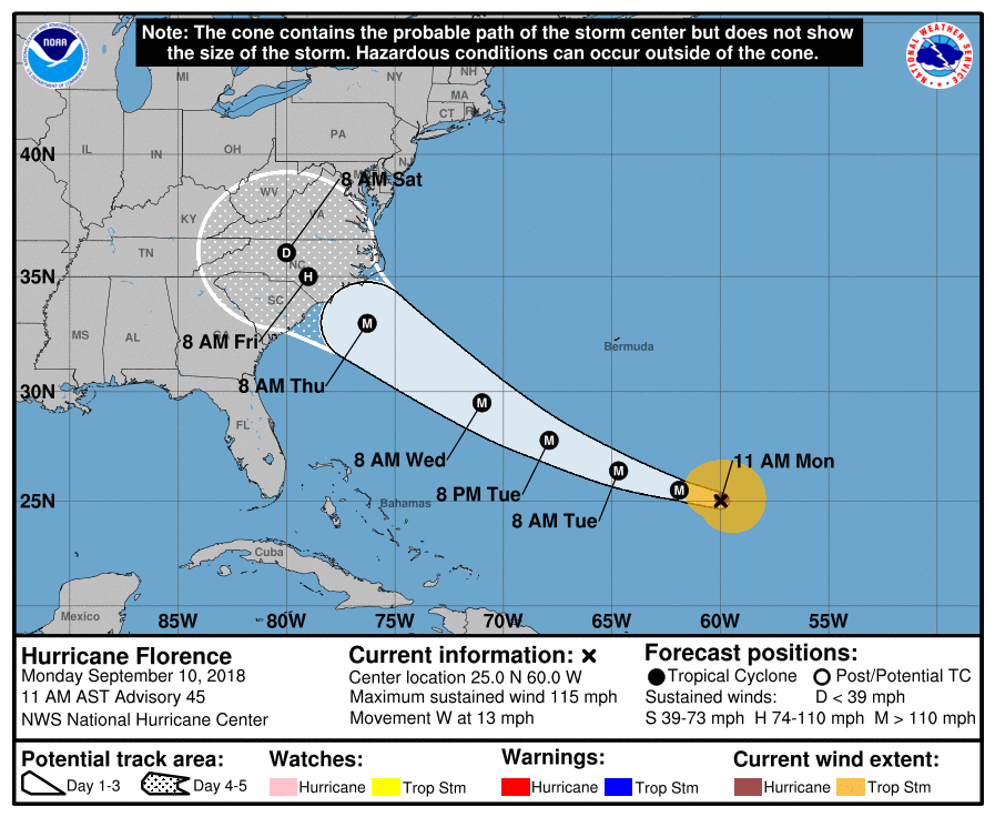
Florence, which is about 580 miles southeast of Bermuda, is moving at a speed of 13 mph (20 km/h), with an increase in forward speed expected during the next couple of days, the hurricane center announced Monday. It is forecast to approach the coast of South Carolina or North Carolina on Thursday.
Swells generated by Florence are already affecting Bermuda and portions of the U.S. East Coast.
“These swells are likely to cause life-threatening surf and rip current conditions,” the hurricane center said.
NEW: Florence is now a category 4 hurricane. Data from a NOAA Hurricane Hunter indicate that Florence has continued to rapidly strengthen and has maximum sustained winds near 130 mph (195 km/h) and a minimum central pressure of 946 mb (27.93 inches) https://t.co/tW4KeGdBFb pic.twitter.com/wfLt6fJPl2
— National Hurricane Center (@NHC_Atlantic) September 10, 2018
CNN meteorologist Chad Myers
said Monday that Florence could be the most powerful storm to strike the area in three decades, and bring water up to 15 feet high along the coast and dump up to 20 inches of rainfall in inland locations over the next four to five days.
The National Weather Service Eastern Region also predicts damaging impacts from heavy rainfall and flooding.
“In addition to potential life-threatening storm surge at the coast, indications are that Florence may slow down by the end of the week, resulting in prolonged heavy rainfall & dangerous freshwater flooding inland. Rainfall forecast is very preliminary, please continue to monitor,” the agency
tweeted Sunday.
In case you're wondering what a category 4 storm surge looks like along the South Carolina coast. This was Garden CIty after Hugo in 1989. GC is 50 miles north of where Hugo made landfall. The storm surge was 14 feet. #scwx #ncwx #Florence pic.twitter.com/t1nX55ekh0
— Ed Piotrowski (@EdPiotrowski) September 10, 2018
The National Hurricane Center advised the region’s residents to have a hurricane plan in place and to follow any advice given by local officials.
The governors of Virginia, North Carolina and South Carolina have each declared states of emergency in anticipation of Florence.
“With this order government agencies will begin to mobilize in anticipation of a hurricane,” South Carolina Gov. Henry McMaster
tweeted over the weekend. “Now is the time for your family also to prepare and stay tuned for more updates. Plan for the worst, pray for the best.”
The National Hurricane Center is also monitoring hurricanes Helene and Isaac in the Atlantic, but they are not expected to hit the U.S. mainland.
Visit Ready.gov for hurricane preparedness tips.
Max sustained winds in #Hurricane #Florence have increased to near 105 MPH with higher gusts. Per @NHC_Atlantic, rapid strengthening is forecast and Florence is expected to become a major hurricane this morning. (@NOAA GOES-16 imagery) pic.twitter.com/gF2jvTxJBZ
— NASA SPoRT (@NASA_SPoRT) September 10, 2018