
 568k
568k  233k
233k  41k
41k  Subscribe

Wildfires, the lowest average extent of Arctic ice, remote villages in the Sahara desert and other striking images were captured by satellites to provide a space-eye view of the Earth during June 2016, compiled by The Guardian.
As seen in the image below stagnant lakes stretch across the upper reaches of the Volga river delta in southern Russia. The lakes are trapped by sandy mounds, created after the Caspian Sea’s level rose then fell in the wake of the last ice age.
 Photograph: Planet
The United Kingdom captured in the image below by the European Space Agency‘s Sentinel-3A satellite on May 9. At top center, aircraft contrails form a cloud-like trail in the sky. At top right, snow covers southern Norway. In the southern English Channel (bottom right), an algae bloom is visible in shades of blue and green.
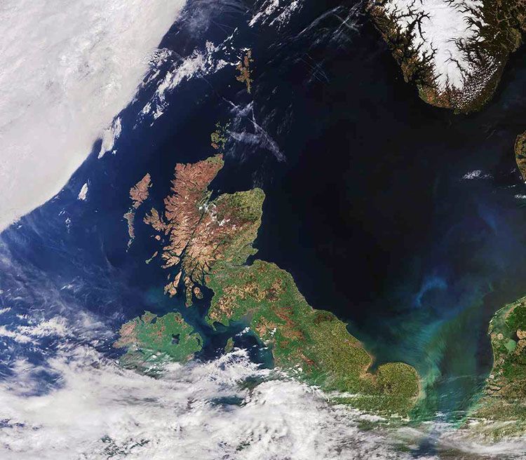 Photograph: Sentinel-3A/ESA
The International Space Station captures the surface of the Sahara desert. The dark patches are date and olive groves in the Bahariya oasis, one of several places in Egypt’s deserts where people can live.
 Photograph: ISS/NASA
The East Siberian sea is covered with ice in the fall and winter, with maximum thickness occurring between February and April. In the spring and summer, ice begins to thin and slowly thaw. In this image, taken June 4, ice has pulled away from the coastline and blue can be seen under the thinning ice.
 Photograph: Modis/Aqua/NASA
The mountains in Mailuu-Suu in southern Kyrgyzstan, labeled as one of the world’s critically polluted areas, are home to radioactive dumps—the product of former Soviet uranium tailing mines.
 Photograph: Planet
Lake Tengiz, is the only large lake (615 square miles) in northern Kazakhstan and is visible from space. The lake’s island and waterways create a habitat suitable for 318 species of identified birds, 22 of which are endangered. Lake Tengiz is the northernmost habitat of the pink flamingo.
The lake is Kazakhstan’s first UNESCO world heritage site.
 Photograph: ISS/NASA
This map created by the National Oceanic and Atmospheric Administration (NOAA) shows the surface temperature of the oceans surrounding North America. The movement of warm water north through the Gulf Stream is clearly displayed.
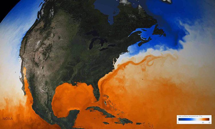 Photograph: NOAA
Arctic sea ice, or the lack of it, can be seen in this picture taken in May. This year has set a record low for the average extent of sea ice in the history of data collection. May 2016’s average extent was 224,000 square miles below the previous record for the month, set in 2004.
 Photograph: Suomi NPP/NASA/NOAA
Snow blankets the mountain peaks in south central Alaska. The mountain range closest to the coast is made up of the Chugach and Kenai mountains in the east and west, respectively. A warm winter and an early, warm spring has created a high fire risk across Alaska.
 Photograph: Modis/Aqua/NASA
Rome’s Lake Albano in the pictures bottom right corner is south of the town of Frascati.
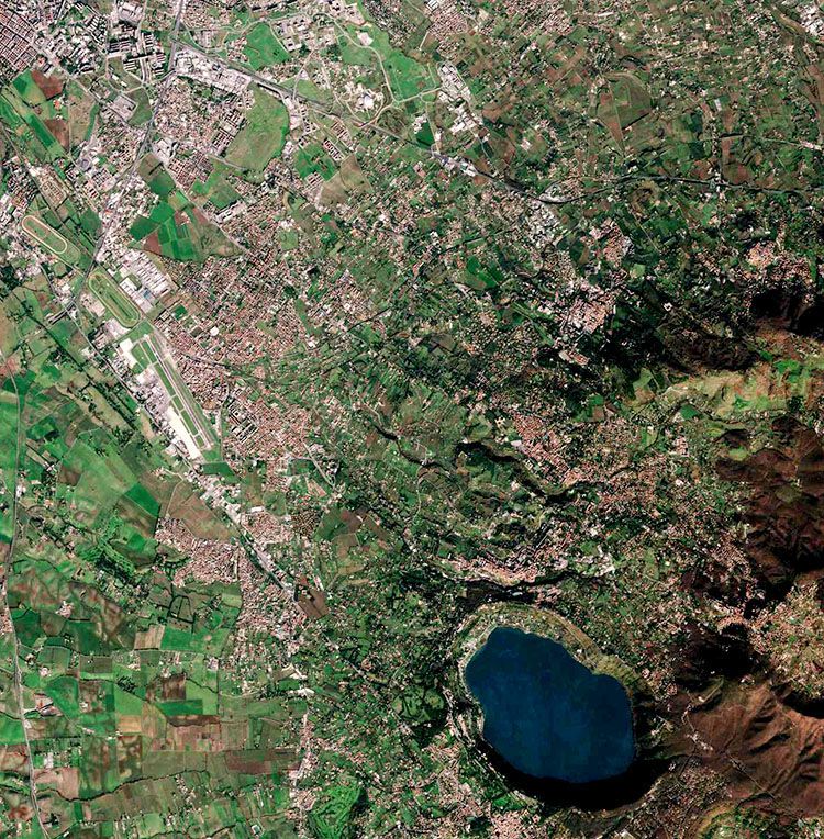 Photograph: Sentinel-2A/ESA
Sleeping Bear Dunes national lakeshore in Michigan and its two nearby islands can be seen in the picture below. The U.S. National Park Service uses images like this one to monitor landscape changes over time.
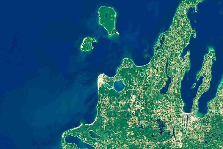 Photograph: OLI/Landsat 8/NASA
A dust storm passes over the Red Sea, a common sight in the area. Gaps in nearby mountain ranges create pathways through which wind carries dust and sand toward the sea. The dust is usually deposited into the sea, providing an important supply of nutrients to the Red Sea.
 Photograph: Modis/Aqua/NASA
Plumes of smoke rise from dozens of large wildfires north-east of Krasnoyarsk in north-central Russia in late June. Many of the fires were triggered by lightning storms. The first are located in isolated areas and do not post threats to population centers.
 Photograph: Modis/Aqua/NASA
A string of wildfires burns in the Sierra Madre mountain forests of western Mexico. Human activities cause an estimated 97 percent of the wildfires, with agricultural and livestock production activity causing 54 percent.
 Photograph: VIIRS/Suomi NPP/NASA/NOAA
Urban Auckland, New Zealand, rests on an ancient volcanic field. Maars (shallow water-filled craters) and cinder cones intermingle with suburban housing developments and city green spaces.
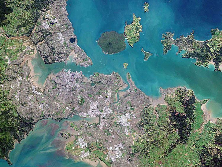 Photograph: Planet
This image of Greece, Turkey and Libya shows their distinct environments. In the middle of the image is the Greek island of Crete, dominated by harsh mountains rising out of the sea, along with natural harbors, coastal plains and the typical Mediterranean scrub. North-west of Crete is a large part of Greece’s mainland, showing dense vegetation and agricultural landscape. Top right is part of south-western Turkey with a mixture of agricultural landscape and mountainous regions, where bare soil and rock formations prevail. At the bottom of the image is Libya’s arid desert, with the Saharan plateau comprising some nine-tenths of the country.
 Photograph: Sentinel-3A/ESA
Streaks of volcanic ash stream from Mount Sourabaya on Bristol Island, one of the remote islands between Antartica and South America, following an eruption that started in late April and continued through mid-June—the first known activity at this volcano since 1956.
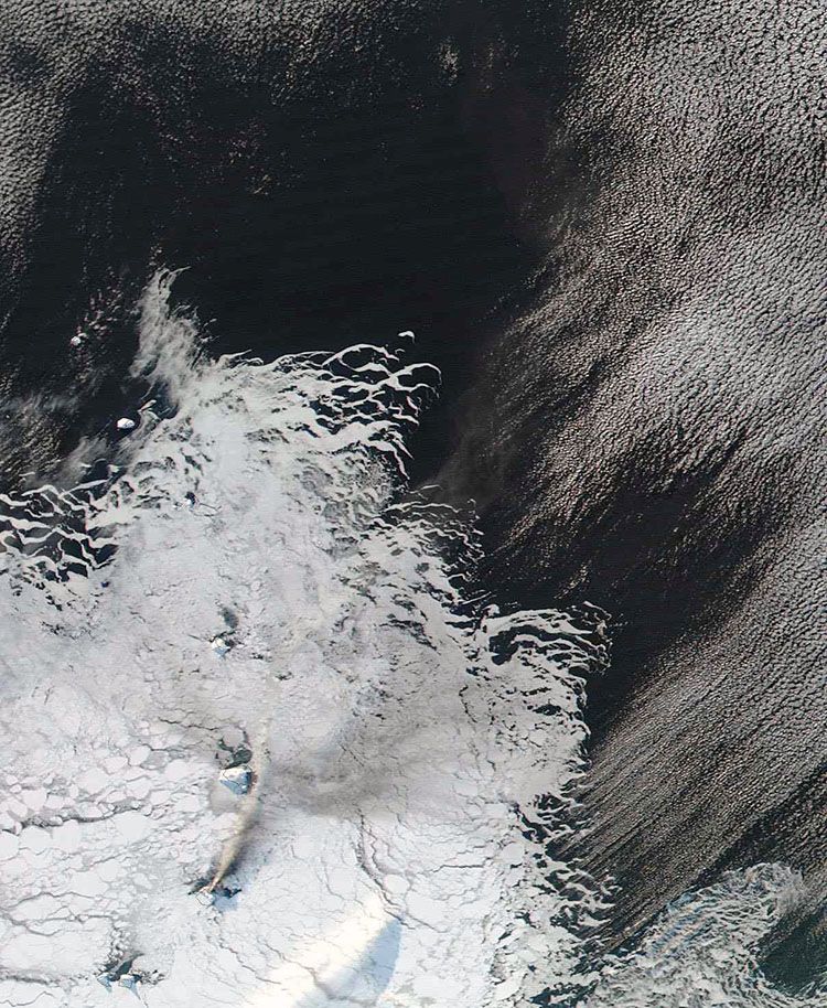 Photograph: Modis/NASA