Iota Becomes Second Major Hurricane to Threaten Central America This Month

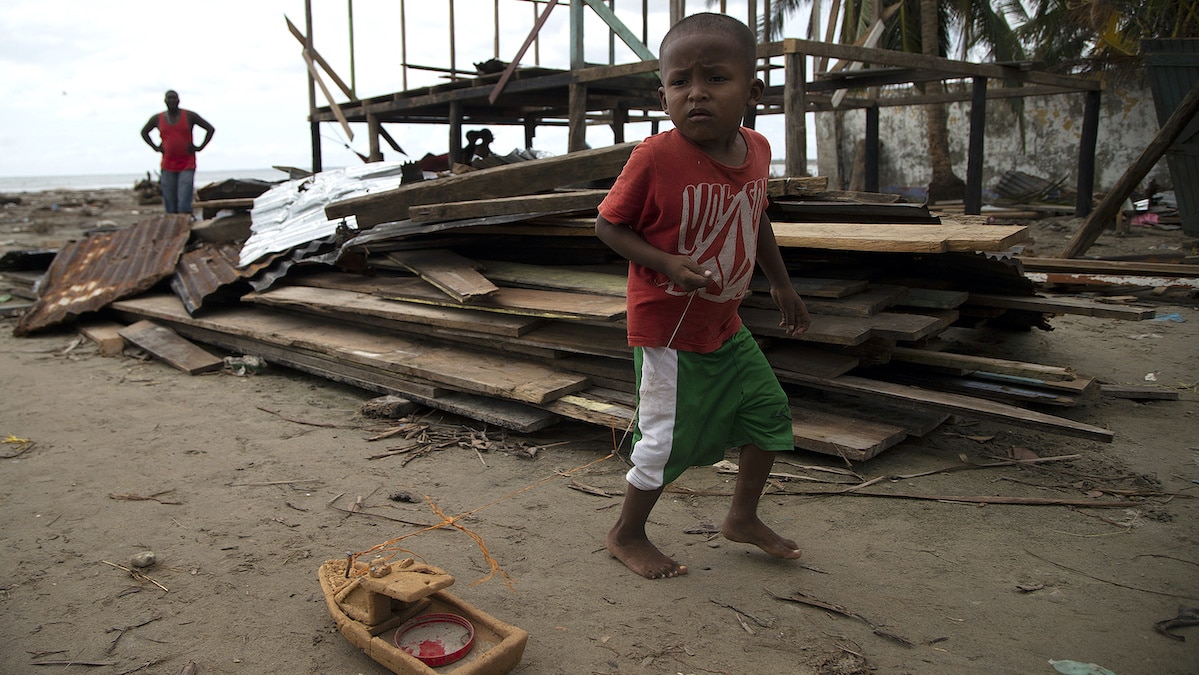
A boy plays in the rubble of his Nicaragua home, destroyed by Hurricane Eta, as Hurricane Iota approaches on Nov. 15, 2020. Maynor Valenzuela / Getty Images
Hurricane Iota, the 30th named storm and 13th hurricane of a record-breaking season, is now bearing down upon Central America less than two weeks after Hurricane Eta devastated the region.
Iota was a Category 1 storm 10 a.m. Sunday, with winds of around 90 miles per hour, The New York Times reported. However, it strengthened rapidly overnight and is now a Category 4 storm with winds up to 155 miles per hour, according to a 7 a.m. EST update from the National Hurricane Center (NHC).
“Iota could be a catastrophic category 5 hurricane when it approaches Central America tonight,” the NHC warned.
#Hurricane #Iota has rapidly strengthened overnight and now has 155 mph (245 km/h) sustained winds. It could reach category 5 status later today before making landfall with 12-18 feet of storm surge. More on this exceptionally dangerous situation: https://t.co/tW4KeFW0gB pic.twitter.com/gNGzvJlPUe
— National Hurricane Center (@NHC_Atlantic) November 16, 2020
Iota is expected to make landfall in northeastern Nicaragua or eastern Honduras Monday night. It threatens a storm surge of up to 12 to 18 feet above normal tide levels, as well as “catastrophic wind damage” as it moves onshore. The NHC predicts it will dump eight to 16 inches of rain on Honduras, northern Nicaragua, Guatemala and southern Belize, with some parts of Nicaragua and Honduras seeing up to 20 to 30 inches.
“This rainfall will lead to significant, life-threatening flash flooding and river flooding, along with mudslides in areas of higher terrain,” the NHC warned.
The situation will likely be made worse by the after-effects of Hurricane Eta, the NHC noted Sunday night.
Hurricane #Iota continues to strengthen. Forecast to become a dangerous category 4 hurricane before it reaches Central America Monday night. Here are the 10 pm EDT Key Messages. For more, visit https://t.co/tW4KeGdBFb pic.twitter.com/rnM1KGDwJr
— National Hurricane Center (@NHC_Atlantic) November 16, 2020
The fact that the soil has not yet dried out after the earlier storm could make landslides and floods even more likely, The Independent explained.
“Our ground is already saturated, so it’s to be expected that we have more farming and infrastructure damage,” Guatemalan President Alejandro Giammattei said, as BBC News reported.
Hurricane Eta killed at least 200 people in Central America. One of the worst tragedies occurred in Guatemala, when mudslides in the village of Quejá buried dozens of homes and likely killed around 100 people. Overall, the storm displaced thousands of people after it made landfall as a Category 4 storm Nov. 3, as CNN reported. More than 3.6 million people in the region were impacted by the storm in some way, the Red Cross said.
Now, Central Americans face further evacuations to prepare for Iota. There are around 63,000 hunkering down in 379 shelters in northern Honduras, The Independent reported. In Nicaragua, 1,500 people were evacuated from low-lying areas as of Sunday afternoon, but 83,000 people in the area were actually in danger.
Both Iota and Eta rapidly intensified, something made more likely by the climate crisis, since warmer water fuels more intense storms.
“In a 36-hour period [Eta] went from a depression to a very strong category 4,” Climate Adaptation Center CEO Bob Bunting told The Guardian. “That is just not normal. Probably it was the fastest spin up from a depression to a major hurricane in history.”
2020 overall has been a record-breaking Atlantic hurricane season, with 30 named storms, the most ever in a single season. But it is less the number of storms that scientists attribute to climate change than their power and substantial rainfall.
The back-to-back attack of Eta and Iota has put Central America in the crosshairs of climate change, but the storms are not the only way that global warming has impacted the region. Drought in an area known as the dry corridor, which stretches from northern Costa Rica to southern Mexico, has devastated subsistence farmers and been linked to migration away from the region.
“Central America is one of the regions where climate change is felt the most,” Guatemala’s Giammattei said, as BBC News reported.
- Tropical Storm Theta Is Record-Breaking 29th Storm of 2020 ...
- Hurricane Eta, 28th Named Storm of 2020, Menaces Nicaragua ...
- Hurricane Iota Breaks Records as It Slams Nicaragua
- Back-to-Back Hurricanes in Central America Push Migrants North, Adding to Humanitarian Crisis

 233k
233k  41k
41k  Subscribe