
 568k
568k  233k
233k  41k
41k  Subscribe
By Kristy Dahl
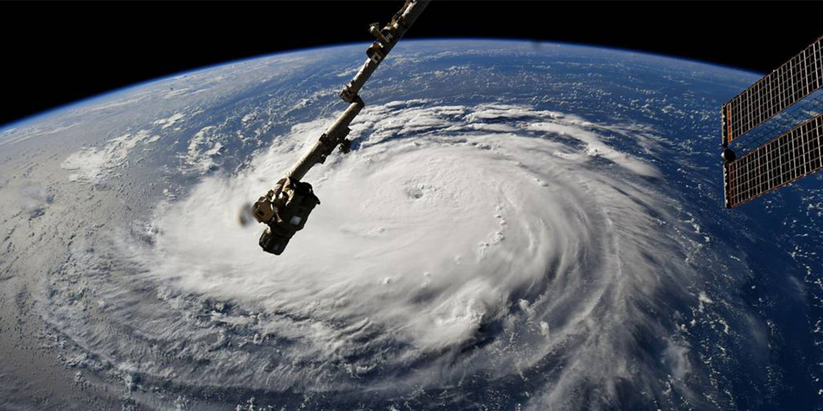
Hurricane Florence is currently making its way as a Category 4 storm toward the southeast coast and is expected to make landfall sometime on Thursday, most likely in North Carolina. Our hearts are with those who are looking at the storm’s predicted path and wondering what this means for their homes, families and communities.
As millions of residents in the storm’s path make preparations to stay safe, our hearts are also with the thousands of people who have faced similar risks in Texas, Florida and Puerto Rico in the past year. If you are in the Carolinas, please do take care to heed local warnings and evacuation orders—and know that we are all hoping for your safety.
Florence, like any hurricane, is a fearsome storm. But the direction and northward extent of Florence’s path make it unusual, and the atmospheric and oceanic conditions in which Florence is brewing are contributing to the storm’s outsized strength for its location. With that in mind, let’s take a look at some of the climate dynamics that make Florence stand out amid our historical knowledge of Atlantic hurricanes.
ONE: Florence’s path is unusual—in a way that’s similar to Sandy’s.
Atlantic hurricanes tend to develop off the coast of Africa, then move in a north/northwest direction. By the time they reach the position Florence was in a couple of days ago, they tend to take a hard right turn toward the north/northeast, staying well away from the U.S. In fact, as reported by Brian McNoldy and the Washington Post, of the nearly 80 recorded storms that passed within 200 nautical miles of Florence’s position on Friday, none made landfall on the U.S. coast.
Florence’s path, however, has been blocked by a ridge of high pressure in the atmosphere, which is essentially blocking the storm from moving northward and keeping it on a westward trajectory toward the coast instead.
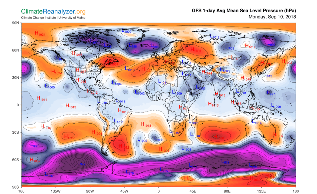
A ridge of high pressure along the northeast coast of North America, shown here in orange, has prevented Hurricane Florence from making the typical northward turn of most hurricanes.
Six years ago, when Sandy slammed into the coast of New Jersey, a “blocking ridge” over the eastern half of northern North America prevented Sandy from moving north. Never before had we seen a hurricane take such a perpendicular path toward the Mid-Atlantic coastline. One important difference between the paths of Sandy and Florence, however, is that during Sandy, the blocking ridge also prevented a low-pressure storm system coming from the west from moving north, so the two storms collided (hence the “Superstorm Sandy” moniker).
TWO: Major hurricanes this far north are rare.
The Southeast U.S. is no stranger to hurricanes. The Carolinas have experienced dozens of hurricanes since modern record-keeping began in 1851. The vast majority of these hurricanes have been Category 1 storms; together the Carolinas have only been hit three times by a Category 4 storm or above. The last time North Carolina was hit by a Category 4 storm was over 60 years ago.
Why is this? Hurricanes require a supply of fuel in the form of warm sea surface temperatures. Historically, as storms moved northward they did so closer to the central Atlantic and they encountered progressively cooler temperatures and weakened. Not so with Florence. While temperatures off the coast of Africa, where most Atlantic hurricanes develop, are running cooler than average right now, Florence’s path, determined largely by the blocking ridge, has taken it westward into a wide swath of the Atlantic where temperatures are running 2 to 3°C above normal. Because of that ridge, even as Florence’s latitude increases, it’s projected to stay within a zone of warm temperatures that will allow Florence to stay strong and indeed strengthen as it churns its way toward the coast.

Over the next few days, Hurricane Florence will encounter abnormally warm sea surface temperatures, which will enable it to remain strong as it churns toward the coast.
We have seen the effects of warmer than average temperatures on hurricanes in the recent past. Last summer, for example, Hurricane Harvey passed over Gulf of Mexico waters that were 2.7 to 7.2°F above average before slamming into the coast and dropping unprecedented amounts of rain on the Houston area. We know that warmer temperatures help to fuel hurricanes and that such conditions are more likely to occur in a warming world.
THREE: The expected storm surge will be amplified by higher average sea levels.
The National Hurricane Center is expected to issue storm surge warnings tomorrow, but residents are already being cautioned that Florence’s storm surge could be life-threatening.
Storm surge is driven by several factors, but its primary driver is wind. As Florence makes its way over more than 1,000 miles of ocean, its winds push surface water toward the coast. That water piles up and creates a surge. The stronger the winds and the farther the storm travels, the bigger the surge. While some storms, like Harvey, cause most of their flooding through intense rainfall, for others, like Sandy, storm surge is the primary cause of flooding.
The last time a Category 4 hurricane made landfall North Carolina was in 1954. Since then, sea level along the coast of the Carolinas has risen roughly 8 inches. That rise is already playing out in the form of increasingly frequent high tide flooding in the region. Charleston, for example, has experienced more than a quadrupling in the number of high tide flooding events just since the 1970s. And when it comes to storm surge, higher sea levels make for larger, farther-reaching surges.
Given that Florence is moving relatively slowly and is predicted to stall over the Southeast or Mid-Atlantic, the storm will likely remain along the coast during at least one high tide cycle. The timing of landfall relative to high tide remains to be seen, but the current state of sea level along the Carolina coast has the potential to add more height to the storm surge, which allows it to reach farther inland, than a storm like Florence would have caused, historically.
FOUR: In a warmer world, the atmosphere can hold more moisture and there is increased potential for extreme rainfall during storms.
Like the rest of the U.S. since the late 1950s, the Southeast has experienced a dramatic increase in the percentage of rain that falls during the heaviest events. This trend has been linked to human-caused climate change because warmer air holds more moisture. And in the case of Hurricane Harvey, human-caused warming was found to have made the storm’s record-breaking rainfall three times more likely and 15 percent more intense.
With Florence’s path through very warm waters, we can expect a lot of moisture with this storm. Current forecasts are predicting 10 to 15 inches of rain for much of North Carolina and Virginia in the next few days.
Just as when Hurricane Matthew hit the region in 2016, the extreme precipitation expected during Hurricane Florence will be falling on already saturated ground. Stream gauges in inland areas of North Carolina and Virginia, where Florence could stall, are recording streamflow—or the flow of water in streams, which is primarily driven by rainfall amounts—”much above normal,” which calls into question just how much more rainfall they’ll be able to accommodate.
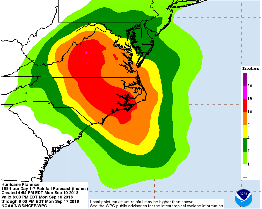
Parts of North Carolina and Virginia could see 10 to 15 inches of rain in the coming days.
The combination of saturated soil and rivers, heavy rainfall and elevated sea levels due to long-term sea level rise and storm surge could make it very difficult for floodwaters to drain after the storm has passed.
As I wrote this, Governor McMaster of South Carolina was telling residents of his state that they should expect more wind than with Hurricane Hugo and more rain than with Hurricane Matthew. As South Carolinian listeners would know, these storms each caused grave damage through their respective mechanisms. In that press conference, the governor also ordered the mandatory evacuation of the state’s entire coastline. This means that more than 1 million people will be fleeing the coast in that state, and more in North Carolina, Virginia and elsewhere. The threat to the coast is the obvious priority as this week gets underway. Later, the challenge of managing the impacts to North Carolina’s interior regions may need to take center stage, as the stalled storm deluges large areas.
People talk about the “calm before the storm” and, if we do things well, there will indeed be an eerie quiet along much of the southeast of the U.S. later this week. In the meantime, as we scramble, hunker down, and prepare to ride out the latest in a terrible spate of hurricanes, we also hope that, unlike with Katrina, Sandy, Harvey and Maria, we don’t surface to find our communities fundamentally scarred by this latest in spate of brutal storms.
We’ll be updating this blog post as conditions continue to evolve.
Category 4 #HurricaneFlorence Forecast to Hit #EastCoast State of emergency declared. https://t.co/4s9L9ngngm
— EcoWatch (@EcoWatch) September 10, 2018