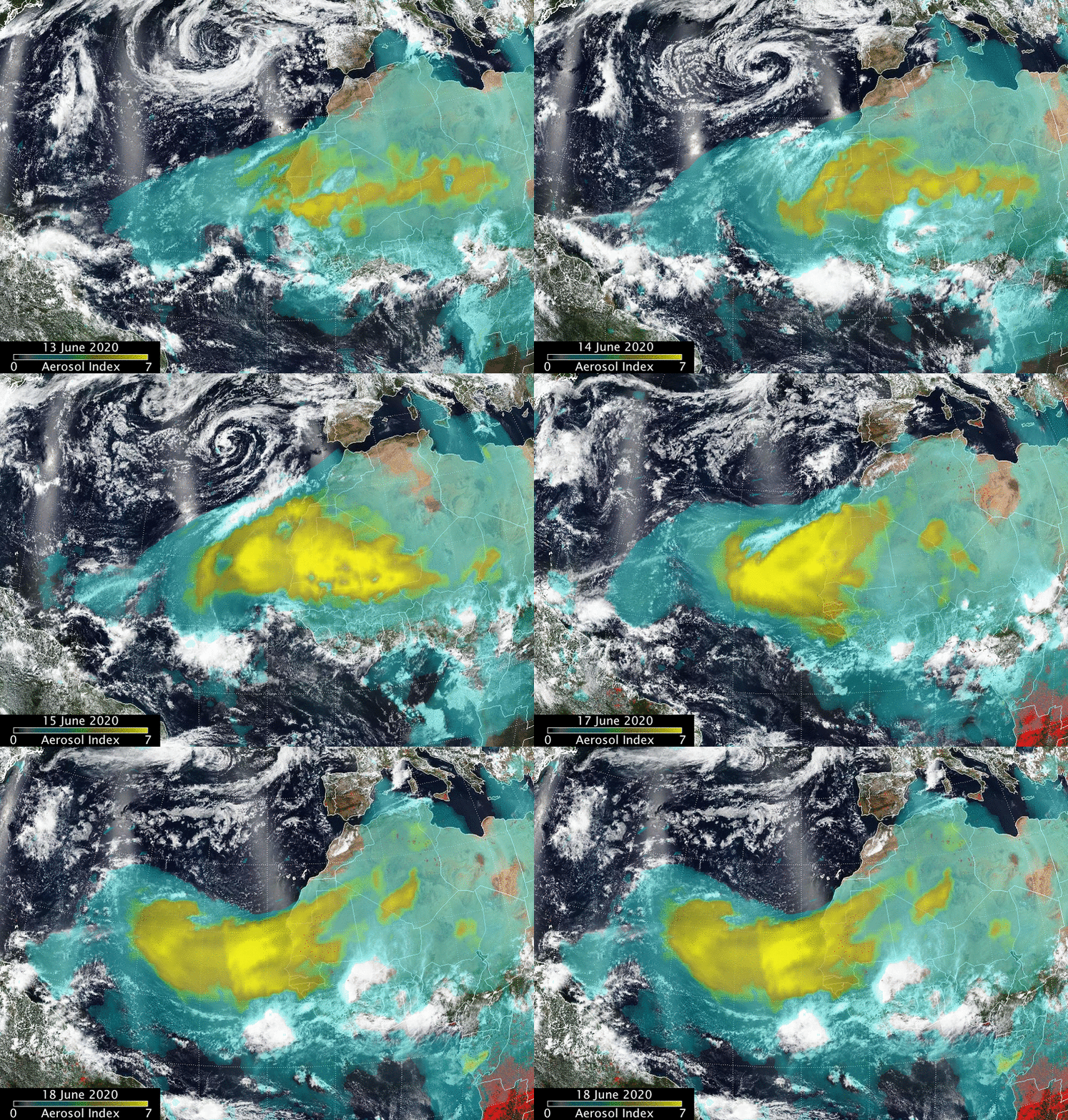
A Massive Dust Cloud Is Moving From the Sahara to the U.S. This Week

An animation shows the movements of the dust cloud from June 13 to 18. NASA/NOAA, Colin Seftor
A massive cloud of dust from the Sahara Desert is expected to reach the Southeastern U.S. by Wednesday.
While the weather pattern driving the cloud is not unusual, the amount of dust is, according to KSLNewsRadio. National Aeronautics and Space Administration (NASA) Colonel Doug Hurley snapped a photo from on board the International Space Station, as NDTV reported.
“We flew over this Saharan dust plume today in the west central Atlantic,” he tweeted Sunday. “Amazing how large an area it covers!”
We flew over this Saharan dust plume today in the west central Atlantic. Amazing how large an area it covers! pic.twitter.com/JVGyo8LAXI
— Col. Doug Hurley (@Astro_Doug) June 21, 2020
The dust is part of something called the Saharan Air Layer (SAL), a mass of dry, dusty air that travels over the North Atlantic every three to five days between mid June and mid August, according to National Oceanic and Atmospheric Administration (NOAA) information reported by KSL.
“Every so often, when the dust plume is large enough and trade winds set up just right, the dust can travel thousands of miles across the Atlantic and into the US.” CNN Meteorologist Haley Brink said.
The current plume emerged off of North Africa last weekend and has already traveled more than 3,000 miles to reach the eastern Caribbean Sea, The Weather Channel reported.
Ok, last dust pic for today and this one is perhaps the most incredible yet. The comparison photos were sent to me from Mirco Ferro who lives in St. Barthelemy. Check the dates in the photos (top is from March) – both are unfiltered or altered in any way. #SAL #DUST pic.twitter.com/FBwOG5ly1E
— Mark Sudduth (@hurricanetrack) June 21, 2020
It covers an area larger than the lower 48 states and Western Europe.
The dust is expected to travel more than 5,000 miles to reach the U.S., according to CNN. But its effects for the country will mostly be positive: brilliant sunsets and suppressed hurricane activity.
A computer model forecast of atmospheric dust for the next 10 days. The plume of Saharan dust is expected to move over the Southeastern US next week. The dust will be primarily at higher altitudes, so the main impact will be some especially colorful sunrises sunsets pic.twitter.com/bBzFp06lCu
— NWS Eastern Region (@NWSEastern) June 19, 2020
The sunsets are because the tiny dust particles tens of thousands of feet in the air filter the sun’s rays at the beginning and end of the day. They also cause a blue sky at midday to have a milky sheen.
The hurricane suppression is because tropical storms don’t do well with dry air.
“The SAL can have a significant negative impact on tropical cyclone intensity and formation,” Jason Dunion explained for NOAA. “Its dry air can act to weaken a tropical cyclone by promoting downdrafts around the storm, while its strong winds can substantially increase the vertical wind shear in and around the storm environment. It is not yet clear what effect the SAL’s dust has on tropical cyclone intensity, though some recent studies have suggested that it can actually impact the formation of clouds.”
However, the cloud could worsen air quality in some places, which could make symptoms worse for people suffering from respiratory conditions like asthma, The Weather Channel pointed out.

 233k
233k  41k
41k  Subscribe