
 568k
568k  233k
233k  41k
41k  Subscribe
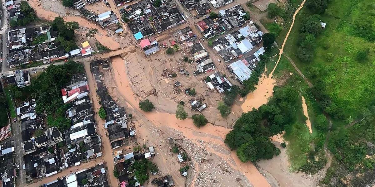
An aerial view of the deadly landslide that followed heavy rains in Mocoa, in the Putamayo region of southwest Colombia, on April 1. Photo credit: Colombian Army
By Jeff Masters and Lee Grenci
At least 254 people were killed in the city of Mocoa (population 40,000) in southwest Colombia near the border of Ecuador early Saturday, when torrential rains triggered a debris flow on a nearby mountain that surged into the town as a huge wall of water carrying tons of mud and debris. The disaster is the fourth deadliest weather-related disaster in Colombia’s recorded history.
Reports from Colombia indicate that 130 mm (5.1″) of rain fell during a short period on Friday night and early Saturday morning, with the heaviest of the rain falling in just two hours, between 11 p.m. Friday, March 31 and 1 a.m. Saturday, April 1. The rains fell on soils that were already wet from unusually heavy rains during March; the Mocoa region received about 50 percent more precipitation than usual during the month of March. The heavy rains of Saturday morning triggered a debris flow down the Taruca ravine on the northwest side of Mocoa and this landslide, accompanied by floodwaters, poured into the Sangoyaco River and rampaged through the city of Mocoa.
According to a USA Today interview with Jonathan Godt, coordinator of the U.S. Geological Survey’s landslide hazards program, “That mixture can move at 35-40 miles an hour and because it’s so dense it has a lot more momentum and destructive power than water alone.”
Contributing Causes to the Disaster
The fundamental cause of the disaster was that the city of Mocoa was situated in a vulnerable location—in a valley surrounded by steep slopes, close to the Mocoa, Mulato and Sancoyaco rivers. Deforestation on the surrounding slopes may have contributed to the landslide and flood. President Juan Manuel Santos blamed climate change for triggering the flood and he has a point—increased evaporation from warming oceans have caused a significant rise in atmospheric water vapor and very heavy rainfall events like the Mocoa event in recent decades.
The Mocoa rains were triggered by a very moist flow of air from the tropical Atlantic, where ocean temperatures were near average (see the meteorological analysis below), The rainy season in Colombia extends from March to mid June, so additional floods and landslides can be expected the next two months.
Colombia’s History of Weather Disasters
According to EM-DAT, the international disaster database, Colombia’s most expensive and second deadliest weather-related disaster occurred in 2010 – 2011, when almost non-stop heavy rains caused three separate billion-dollar flooding events, killing 418 people. EM-DAT lists one other flood that killed more than 200 people in Colombia: a December 1971 flood in Magdalena and Cauca Valsfive that killed 307. EM-DAT also lists five landslides in Colombia’s history that have killed at least 200 people:
- 640 killed in Villatina on Sep 27, 1987
- 300 killed in Quebrada Blanca on June 28, 1974
- 200 killed in Bogota on June 28, 1973
- 200 killed on June 21, 1986
- 200 killed in December 1971
Meteorology of the Disaster
Wunderblogger Lee Grenci looked in detail at the meteorology of the disaster and what follows is his analysis.
Below is the animation of enhanced satellite images from GOES-13. You can see a mesoscale convective system (MCS). This may more properly have been called a mesoscale convective complex, given the symmetry of the cirrus canopy toward the end of the loop. Needless to say, the MCS was slow-moving, if not stationary, for several hours. The cloud-top temperatures at the peak of deep, moist convection were as low as -90 degrees Celsius, indicative of heavy thunderstorms quite capable of producing very heavy rain.
 The animation of enhanced infrared images from GOES-13 during the period, 0045 UTC to 0715 UTC on April 1.Penn State
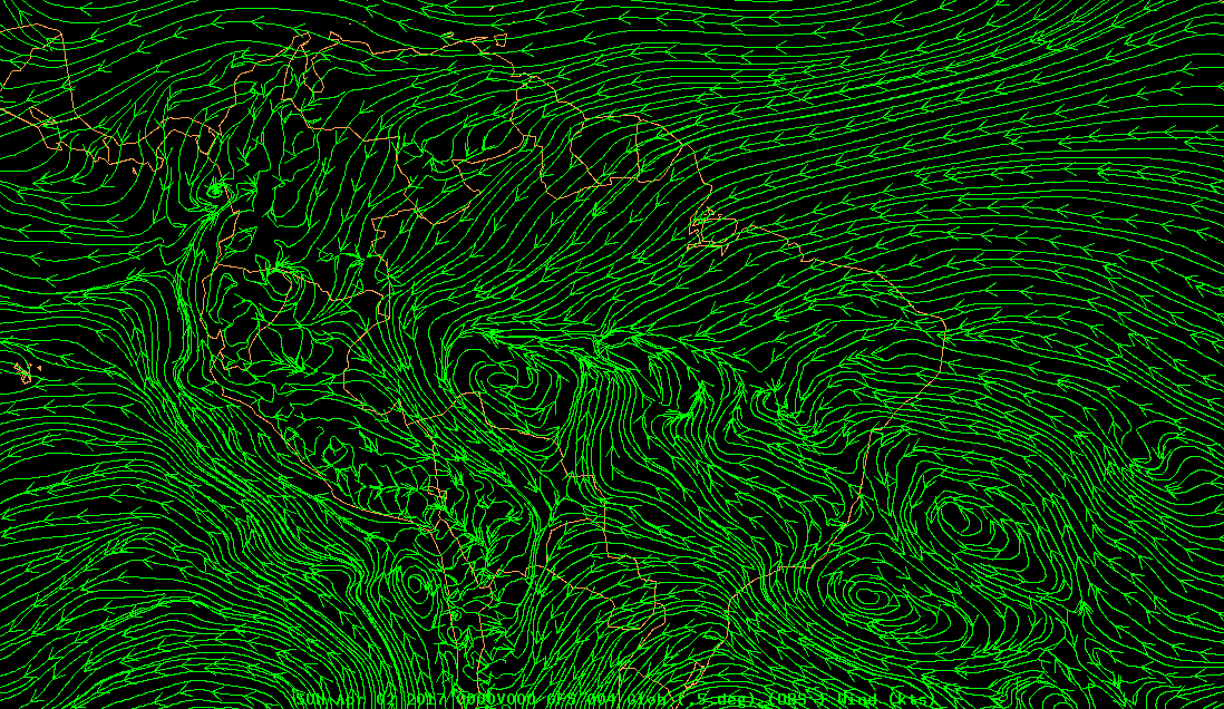
Given the quasi-stationary nature of the MCS, it’s pretty clear that the initiation of heavy thunderstorms was orographic in nature. Check out (below) the GFS model analysis of 700-mb streamlines (about 10,000 feet) at 00 UTC on April 2. Please note that I’m using 700 mb as a proxy for the lower troposphere, given the high elevations in this region (mountains to the west of Mocoa are as high as 15,000 feet). The analysis shows a strong easterly flow from the tropical Atlantic that moved upslope over the high terrain, paving the way for heavy thunderstorms. The rapid, extreme run-off from the lofty mountains set the stage for devastating flooding and mudslides.
 The GFS model analysis of 700-mb streamlines at 00 UTC on April 2.Penn State
 The GFS model analysis of 850-mb streamlines at 00 UTC on April 2. Lower-level winds come into South America from the tropical Atlantic and Caribbean. Penn State
Moisture from the Caribbean, where ocean temperatures were up to 1°C (1.8°F) above average might have played a role in the MCS, but I believe the mountains to the north probably blocked some of this low-level moisture. To support my claim, take a look at the GFS analysis of precipitable water (PWAT, Figure 7). In my opinion, the broad east-to-west band of high PWAT, with an embedded area of 2.5+ inches, was aimed (given the prevailing easterly flow) directly at the location of the MCS.
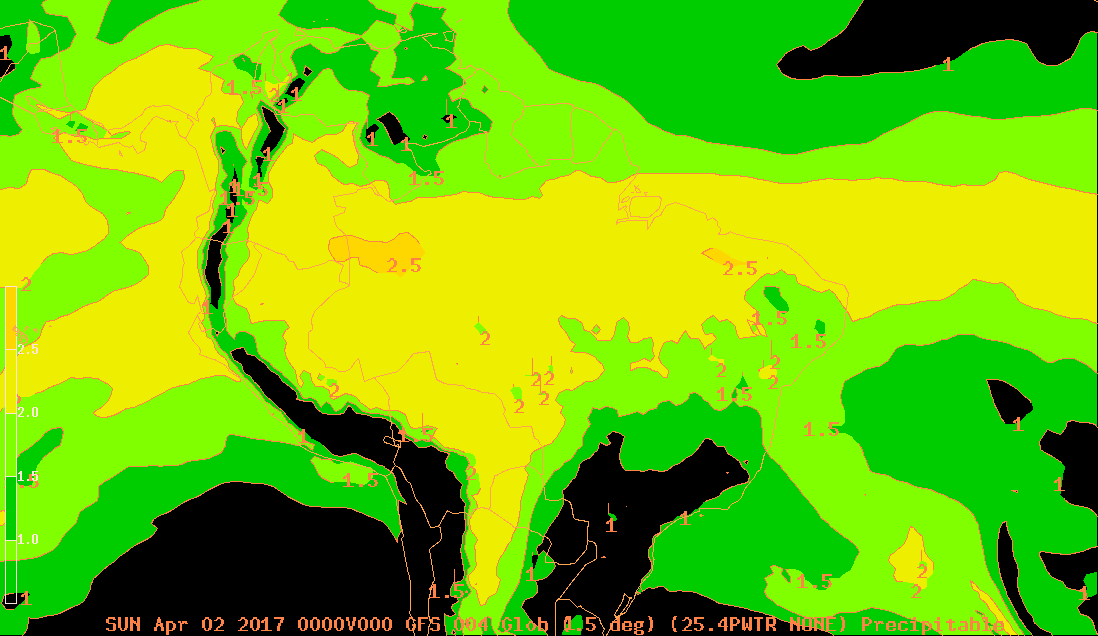 The GFS model analysis of precipitable water (PWAT expressed in inches) at 00 UTC on April 2. Larger image.Penn State
Reposted with permission from our media associate Weather Underground.